logo
  • Home
  • His life ...
    • Biography
    • Curriculum Vitae
    • Book: “Maximilien au Désert” NEW !
  • His work ...
    • Books
    • Expos
    • Painting
    • Embossings
    • New Year's wishesNEW !
    • Online ExhibitionsNEW !
    • Slideshows
  • Media ...
    • Documentation
    • Videos
    • Contact
  • Photo Gallery ...
    • All Photos
    • -
    • Sahara Rock Art completed
    • Tuareg
    • Pueblos
    • Northwest Indians
    • Peru
    • The culture of the Incas
    • Pre-Inca cultures
    • The Northern Andes Expanded!
    • The Central Andes Expanded!
    • The Southern Andes Expanded!
    • Argentina
    • Gauchos
    • Central America
    • Sahara 1962-1975
    • Sahel
    • Sahara : Tassili - Tadrart 1993
    • From the Ténéré to the Aïr Mountains
    • In the dunes of Erg Izane
    • Across the Tamgak Mountains
    • From Adrar Bous into the Tamgak Mountains
    • With the Tuareg on the edge of the Tamgak Mountains
    • Building a Tataram: Documentation
    • The Spice Route – Spices NEW !
    • The Spice Route – Java and Sulawesi NEW !
    • The Spice Route – Moluccas NEW !
    • The Spice Route – Malaysia, Singapore and Sri Lanka NEW !
    • The Spice Route – India : Kerala, Goa and Mumbai NEW !
    • The Spice Route – India: Rajasthan NEW !
    • The Spice Route – Africa – Europe NEW !
  • Comments
    flag flag flag flag    

Description

  • Foto Number: AND-141

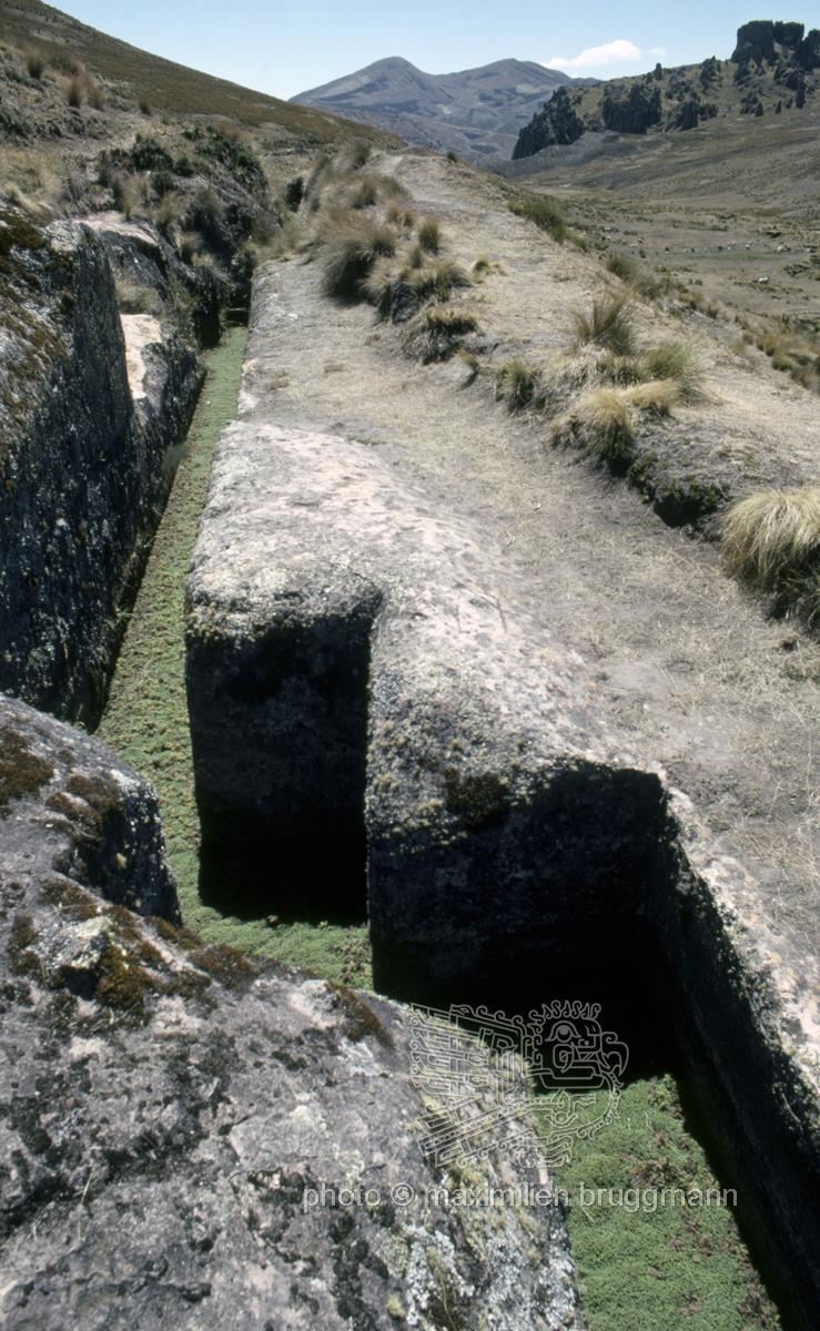
Cumbemayo, 19 km south-east of Cajamarca in Peru, at an altitude of around 3,500 metres. The aqueduct is approximately 850 metres long, hewn from rocky volcanic rock, and forms part of an 8-kilometre-long canal. It was built around 1500 BC. The precisely carved zigzag angles served to reduce the flow velocity of the water and prevent soil erosion. The name Cumbemayo may have its roots in the Quechua expression ‘kumpi mayu’, literally ‘well-built water channel’. There are petroglyphs on the aqueduct and in the surrounding caves. – Peru – 1976
  • Keywords:
    South America Peru Cajamarca Cumbe Mayo Andes Central Andes Aqueduct

Description

  • Foto Number: AND-141

Cumbemayo, 19 km south-east of Cajamarca in Peru, at an altitude of around 3,500 metres. The aqueduct is approximately 850 metres long, hewn from rocky volcanic rock, and forms part of an 8-kilometre-long canal. It was built around 1500 BC. The precisely carved zigzag angles served to reduce the flow velocity of the water and prevent soil erosion. The name Cumbemayo may have its roots in the Quechua expression ‘kumpi mayu’, literally ‘well-built water channel’. There are petroglyphs on the aqueduct and in the surrounding caves. – Peru – 1976

  • Keywords:
    South America Peru Cajamarca Cumbe Mayo Andes Central Andes Aqueduct

Website © 2026 pb + StratLabs
Copyright © Estate of Maximilien Bruggmann for all photos. Any use for commercial purposes prohibited.
flag flag flag flag