logo
  • Home
  • Su vida ...
    • Biografía
    • Curriculum Vitae
    • Libro: “Maximilien au Désert” NUEVO !
  • Su obra ...
    • Libros
    • Exposiciones
    • Pinturas
    • Gofrados
    • Deseos de Año NuevoNUEVO !
    • Exposiciones en líneaNUEVO !
    • Slideshows
  • Medios ...
    • Documentación
    • Videos
    • Contacto
  • Galería de fotos ...
    • Todas las fotos
    • -
    • Arte rupestre en el Sahara completado
    • Tuareg
    • Pueblos
    • Indios del noroeste
    • Perú
    • La cultura de los incas
    • Culturas preincaicas
    • Los Andes
    • Argentina
    • Gauchos
    • Centroamérica
    • Sahara 1962-1975
    • Sahel
    • Sahara : Tassili - Tadrart 1993
    • Del Teneré al Aïr
    • En las dunas del Erg Izane
    • Por los montes Tamgak
    • De Adrar Bous a los montes Tamgak
    • Con los tuaregs al borde de los montes Tamgak
    • Construir un Tataram: Documentación
    • La Ruta de las Especias – Especias NUEVO !
    • La Ruta de las Especias: Java y Sulawesi NUEVO !
    • La Ruta de las Especias – Molucas NUEVO !
    • La Ruta de las Especias: Malasia, Singapur y Sri Lanka NUEVO !
    • La Ruta de las Especias – India : Kerala, Goa y Bombay NUEVO !
    • La Ruta de las Especias – India: Rajastán NUEVO !
    • La Ruta de las Especias – África – Europa NUEVO !
  • Comentarios
    flag flag flag flag    

Descripción

  • Número de la foto:: PUE-026

Las leyendas solo están disponibles en alemán o inglés
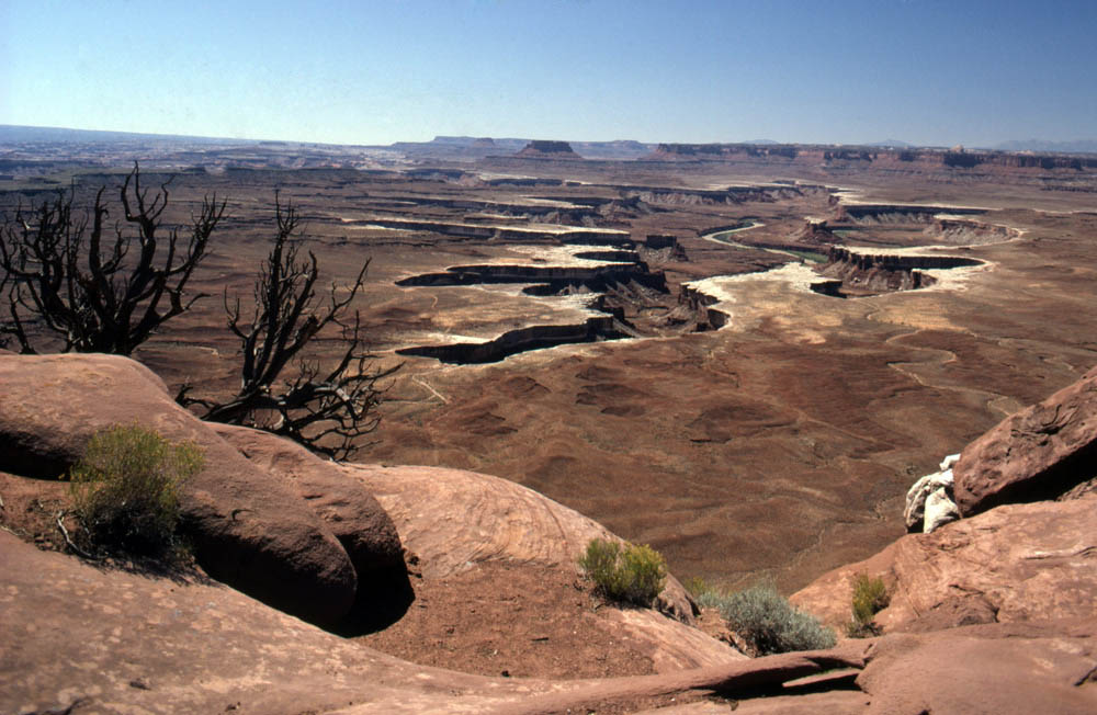
View of the Green River as it flows through Canyonlands National Park (Utah), created in 1964. The river was given its name in the 16th century by the Spaniards, impressed by the bordering vegetation, rare in the parched landscape, which was reflected in the water.

  • Palabras clave:
    América del Norte USA Utah Canyonlands NP Green River Pueblos paisaje quebrada río

Descripción

  • Número de la foto:: PUE-026

Las leyendas solo están disponibles en alemán o inglés
View of the Green River as it flows through Canyonlands National Park (Utah), created in 1964. The river was given its name in the 16th century by the Spaniards, impressed by the bordering vegetation, rare in the parched landscape, which was reflected in the water.

  • Palabras clave:
    América del Norte USA Utah Canyonlands NP Green River Pueblos paisaje quebrada río

Website © 2026 pb + StratLabs
Copyright © Estate of Maximilien Bruggmann para todas las fotos. Cualquier uso para fines comerciales está prohibido.
flag flag flag flag